

Süni intellekt və peyk təsvirləri Koloradoda meşə yanğınlarını böyümədən aşkar etməyə necə kömək edir
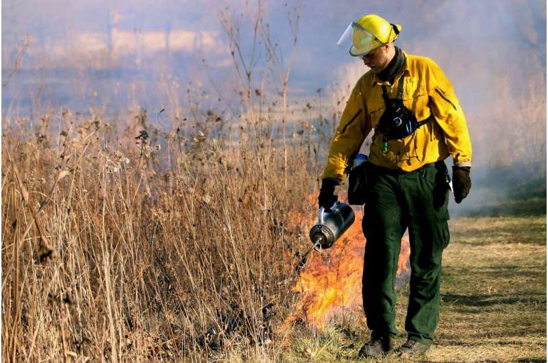
Yeni süni intellekt proqramı Yer səthindən təqribən 22.000 mil yüksəklikdə orbitə çıxan hava peykləri tərəfindən çəkilmiş şəkilləri skan edərək, akr kimi kiçik meşə yanğınlarını müəyyən etməyə kömək edəcək.
Milli Okean və Atmosfer Administrasiyası tərəfindən hazırlanmış və bu yaxınlarda Boulderdə sınaqdan keçirilmiş süni intellekt proqramı yanğının müəyyən edilməsi ilə reaksiya vermə arasındakı vaxtı kəskin şəkildə azalda bilər – alovun qarşısını almaq üçün vacib olan dəqiqələr və saatlar.
Yeni Nəsil Yanğın Sistemi adlandırılan NOAA rəsmiləri deyirlər ki, o, peyklərdən gələn məlumatların daşqınlarını emal edə bilir – bu, hər 30 saniyədə tez-tez şəkillər çəkir – və futbol meydançasından daha kiçik yanğınlardan gələn istiliyi aşkar edir. Daha sonra proqram potensial yeni yanğınları idarə panelində qeyd edir ki, insanlar şəkilləri yoxlaya və yanğının mövcudluğunu yoxlaya bilsinlər.
NOAA Satellites-in Wildland Fire Proqramının meneceri Mayk Pavolonis deyib ki, insanlar peyk görüntülərindən yeni yanğını aşkar etməkdə əla olsalar da, məlumatları AI proqramı qədər tez və asanlıqla emal edə bilmirlər.
“Vəhşi ərazilərdə yanğınların idarə edilməsində ilk addım yanğının orada olduğunu bilməkdir” dedi.
Keçən ay Yeni Nəsil Yanğın Sistemi ilk əhəmiyyətli sınaq imtahanından keçdi, hava proqnozları, dövlət meşə yanğınları menecerləri və tədqiqatçılar yeni alətdən istifadə edərək simulyasiya edilmiş yanğın ssenariləri ilə işləmək üçün Boulderdə toplandılar. NOAA-nın Yanğın Havası Test Yataqı agentliyin Boulder ofisində yerləşir və yanğına qarşı mübarizədə yeni texnologiyanı inteqrasiya etmək və ölkə daxilində yanğın mütəxəssislərini birləşdirmək məqsədi daşıyır.
Fire Weather Testbed meneceri Zak Tolbi deyib ki, sınaqlar uğurla keçib. Onun sözlərinə görə, Next Generation Fire System təxminən bir ildir ki, eksperimental formada onlayndır, lakin agentliklər indi ondan real vaxt rejimində istifadə etməyə başlayırlar.
https://googleads.g.doubleclick.net/pagead/ads?gdpr=0&us_privacy=1—&gpp_sid=-1&client=ca-pub-0536483524803400&output=html&h=135&slotname=8188791252&adk=2329133447&adf=1857921027&pi=t.ma~as.8188791252&w=540&abgtt=6&fwrn=4&lmt=1722505652&rafmt=11&format=540×135&url=https%3A%2F%2Fphys.org%2Fnews%2F2024-07-ai-satellite-imaging-wildfires-colorado.html&wgl=1&uach=WyJXaW5kb3dzIiwiMTUuMC4wIiwieDg2IiwiIiwiMTI3LjAuNjUzMy43NCIsbnVsbCwwLG51bGwsIjY0IixbWyJOb3QpQTtCcmFuZCIsIjk5LjAuMC4wIl0sWyJHb29nbGUgQ2hyb21lIiwiMTI3LjAuNjUzMy43NCJdLFsiQ2hyb21pdW0iLCIxMjcuMC42NTMzLjc0Il1dLDBd&dt=1722502350738&bpp=1&bdt=286&idt=456&shv=r20240729&mjsv=m202407310101&ptt=9&saldr=aa&abxe=1&cookie=ID%3D6bf3eefe49031f83%3AT%3D1721367059%3ART%3D1722505430%3AS%3DALNI_MacAfAOJA8VyURIyKJCZKOtEk96_Q&eo_id_str=ID%3D253fe466b124068d%3AT%3D1721367059%3ART%3D1722505430%3AS%3DAA-Afja3CR3UFVWEVuVSmzApOeu3&prev_fmts=0x0%2C1519x695&nras=2&correlator=2419789169666&frm=20&pv=1&rplot=4&u_tz=240&u_his=1&u_h=864&u_w=1536&u_ah=816&u_aw=1536&u_cd=24&u_sd=1.25&dmc=8&adx=395&ady=2080&biw=1519&bih=695&scr_x=0&scr_y=0&eid=44759876%2C44759927%2C44759837%2C44795922%2C95333410%2C95334528%2C95334830%2C95337869%2C31085793%2C95339220%2C95336266%2C31078663%2C31078665%2C31078668%2C31078670&oid=2&pvsid=3722938207069966&tmod=536144941&uas=0&nvt=1&ref=https%3A%2F%2Fphys.org%2Fpage2.html&fc=1920&brdim=0%2C0%2C0%2C0%2C1536%2C0%2C0%2C0%2C1536%2C695&vis=1&rsz=%7C%7CpeEbr%7C&abl=CS&pfx=0&fu=128&bc=31&bz=0&td=1&tdf=0&psd=W251bGwsbnVsbCwibGFiZWxfb25seV8xIiwxXQ..&nt=1&ifi=2&uci=a!2&btvi=1&fsb=1&dtd=M
Tolbi bildirib ki, alət tüstünün haradan qaynaqlandığını tapmaqdan daha dəqiq olan şübhəli yanğının GPS yerini təmin edir. O, həmçinin ərazidəki yanacaqlar və yanğının davranışına təsir edə biləcək potensial hava haqqında məlumat verir.
Tolbi deyib ki, proqram daha az insan və resursların olduğu ərazilərdə xüsusilə əhəmiyyətli olacaq.
“In populated areas, 911 gets called pretty quickly when there is new smoke,” he said. “But that’s not the case in more rural areas.”
Advanced tools to help identify and fight fires are critical as wildfires across the West become larger and more devastating due to drought, climate change and decades of fire suppression. In Colorado, 20 of the state’s largest wildfires have ignited since the start of the new millennium, according to the Colorado Division of Fire Prevention and Control.
Similarly, all of the most destructive fires in state history burned in the last 12 years, including the 2021 Marshall fire.
“Wildland fire is a growing crisis and wildland fire managers are in need of better tools,” Pavolonis said. “That’s really the role of tech: To make decision-making more efficient and effective for humans, who are making really big decisions about people and resources.”
The NOAA’s artificial intelligence program is one of several projects across the West that leverage the power of AI to detect and fight wildfires.
Several governments and companies in Colorado contract with Pano AI, which installs a network of cameras and uses AI to monitor the video feeds for smoke. Xcel Energy Colorado, the Telluride Fire Protection District, the Aspen Fire Department and others have hired the company.
State lawmakers in 2023 introduced a bill that would have set aside $2 million for camera systems that detect wildfires using AI, but the bill failed.
The federal government in recent years has poured millions of dollars into new technologies to predict, detect and fight fires. Funding for the Fire Weather Testbed and the Next Generation Fire System was part of a $5 billion allocation for wildland fire issues in the Bipartisan Infrastructure Law.
“Rising temperatures, declining snowpack and frequent droughts are all leading to a dramatic surge in wildfire frequency and severity across the United States,” NOAA Administrator Rick Spinrad said in a news release about the Bipartisan Infrastructure Law funding. He said the investments would help develop new tools to improve the accuracy of forecasts as well as “assist local officials’ decision-making and communicate vital public safety information to more people more quickly.”
The NOAA for decades has used weather satellites to help detect wildfires, but the technology has advanced rapidly over the last few years and is becoming more useful in times of fire, Pavolonis said.
It is also creating an AI program that can detect lightning strikes—and predict where lightning might strike next and whether it will spark a fire in a given area—based on the weather, fuels and other factors.
“The rate at which progress has been made on this has been pretty exciting,” Pavolonis said.
2024 MediaNews Group, Inc. Tribune Content Agency, LLC tərəfindən paylanmışdır.